-
Digi-Nauten: Video series and activity book on digital citizenship competencies

Digi-Nauten is a video series and activity book from the Council of Europe. It encourages young children, with the help of parents or teachers, to think about their participation in the digital society. There is a video about it:
- inclusion, …
Translated by
 WebsiteNew
-
Go goals: SDG board game

The game is intended to inform children and young people around the world about the sustainable development goals in a simple and child-friendly way.
Translated by
Downloadable resourceTeacher -
European Union: Map
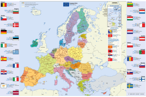
Map of the European Union, Dutch (or in another European language), in A4 format.
You will find this information per country: flag, capital, area, population, currency.
You can download or order this map.
Translated by
Downloadable resource
-
European Union: Poster

This poster shows the map of Europe, together with the euro notes and coins. The national characteristics and traditions of each country are displayed. The countries of the eurozone are indicated by a euro coin next to their name.
Translated by
Downloadable resource (3)Organisation, company, NPO -
Our planet, our future: Informative site with worksheets

Our planet, our future is an online platform that can help young people to better understand the causes and consequences of climate change, while offering solutions on how to make our society climate-friendly. The platform combines science, …
Translated by
Downloadable resource (3)Organisation, company, NPO -
BABADADA: Picture dictionary in different languages

Discover more than 1000 prints with descriptions in two languages.
The images are sorted by theme (body, school, colors, house, ...) and you can choose from 90 languages. Some examples:- Dutch - Arabic ,
- Polish - English ,
- French - Hebrew , …
Translated by
Website (67)Teacher, Learning mentor -
Global Footprint calculator

The user chooses its country on a map and the language to use. After he has to answer a series of questions about he's consumption habits, mobility, food, etc.
In the end he will see the results of he's ecological footprint in terms of the number of …
WebsiteTeacher, ICT co-ordinator, … -
Toporopa: Topography of Europe

Toporopa is intended for anyone who wants to get to know the topography of Europe better. Various things can be practiced here: Euro countries, rivers, mountain ranges, monarchies, seas, metropolises, islands, capitals, volcanoes, flags, ports, …
Translated by
Website (19)Teacher -
Database of photos related to Classical Antiquity

It's actually a 'group' on the very extensive Flickr photo site. Photos (about 12000) are collected in this group, all of which relate to Classical Antiquity.
The interesting thing is that the photos all come from amateur photographers …
Translated by
Website (7)Teacher -
Nik-nak: Bilingual reading books

The small books from nik-nak are ideal for a storytelling bag that goes home or for in the reading case. They are especially ideal for multilingual classes. In each booklet, Dutch is put next to another language. For example, there are different …
Translated by
Tangible material (5)
-
World of Where: A brief atlas in quiz form

World of Where is an atlas with colorful cards that are easy to interpret, and especially those in their state capitals.
World of Where also contains a database with flags of each country (or sometimes even from the provinces). Also included are …
Translated by
App or softwareTeacher, Schoolboard
Yummmm… cookies!
We don't like being tracked either. That's why we're concerned about your privacy.
Necessary cookies: for the proper operation of the website.
Functional cookies: for your convenience. recommended
Social media cookies: to view embedded media such as videos from YouTube, Facebook … recommended
Statistical cookies: for anonymous data collection to enhance user experience.